Route 66 - The Mother Road
National Historic Civil Engineering Landmark
OVERVIEW
The year 2026 marks the 100th anniversary of Route 66 as the first paved, all-weather highway in the United States connecting the Midwest to California.
In celebration of the Centennial, 10 Sections of the American Society of Civil Engineers representing the 8 states through which Route 66 passes, from Chicago, Illinois, to Santa Monica, California jointly nominated the route as a National Historic Civil Engineering Landmark.
This site is a repository for historical information and accounts of the activities of numerous organizations that are involved in the preservation of Route 66 as a national treasure.
The states that are home to Route 66, from east to west, are Illinois, Missouri, Kansas, Oklahoma, Texas, New Mexico, Arizona, and California.
The American Society of Civil Engineers (ASCE) has a program to recognize historically significant local, national, and international civil engineering projects, structures, and sites. Recognition is defined by ASCE as being selected as a "National Historic Civil Engineering Landmark (NHCEL)."
The purpose of the program is to increase public appreciation of civil engineering contributions to the progress and development of society. Preservation of historic civil engineering contributions includes documentation of landmarks for inclusion in encyclopedias, guidebooks, and maps.
The above link, "NOMINATION PACKAGE", will display the master Route 66 Nomination page with an interactive map showing the alignment from Chicago to Santa Monica with links to pages for each state through which Route 66 passes, as well as driving distance from any location to major cities along the route. The master page also contains links to pages describing the historic significance of the project, comparable or similar projects, contributions which this project has made toward the development of the Civil Engineering Profession and the nation, unique features of Route 66, resolutions adopted by the 10 ASCE Sections endorsing the nomination, and additional documentation as required by ASCE guidelines.
Each state's home page contains an interactive map with links to pages listing Key Professionals who were involved in the development of Route 66, a list of locations on Route 66 that have been designated by the National Park Service in its National Register of Historic Places as being worthy of preservation, references specific to each state, and a link to pages with interactive maps showing the location of bridges on Route 66 in that state. On the sidebar of each state's home page is a table with links to additional interactive pages which divide the route into enlarged segments with links to historic alignments within those segments, as well as links to web pages which contain information about Route 66 in the towns through which Route 66 passes.
An application using the ASCE standard form was submitted to ASCE on July 1,2024 to allow sufficient time for review by the ASCE History & Heritage Committee prior to the Route 66 Centennial in 2026.
On July 10, 2025, the Board of Directors of ASCE approved the designation of Route 66 from Chicago, Illinois, to Santa Monica, California, as a National Historic Civil Engineering Landmark and named fifteen locations on the route as select civil engineering features. A web site for each of the features can be accessed at
https://www.route66nhcel.net/FifteenNotableFeatures/FifteenNotableFeatures.htm and a breakdown of the nomination package by section can be accessed at https://www.route66nhcel.net/ApprovedNomination/ApprovedNomination.htm
here.
The Route 66 Road Ahead Partnership developed the Route 66 Centennial Website. The Road Ahead Partnership is an organization established in 2016 (with support from the National Park Service and World Monuments Fund) to revitalize and sustain Route 66 as both a national icon and an international destination. Its mission centers on benefiting Route 66 communities, travelers, and businesses by fostering collaborative partnerships focused on five pivotal pillars: Promotion, Preservation, Research and Education, Economic Development, and Collaboration.The Road Ahead operates grant initiatives like the Route 66 Preservation and Economic Development Grant Program, offering small grants to help businesses and attractions along Route 66 preserve, restore, or reopen for the upcoming 100th anniversary in 2026.
The Calendar of Events will be continuosly updated to show the date, time, and place of each event along with links to the website of the Section staging the event. The calendar can be accessed here
Nominating Team
Brian Pawula, P.E.
Illinois Section
Christopher Gutkowski, P.E.
Central Illinois Section
Jeffrey Fouse, P.E.
St. Louis Missouri Section
Tony Kulesa, P.E.
Kansas City Section
Ben Ware, P.E.
Kansas Section
Josh Johnston, P.E.
Oklahoma Section
Melinda Luna, P.E.
Texas Section
Roger Zimmerman, P.E., PhD
New Mexico Section
Bill Lawson, P.E.
Los Angeles Section
Andrew Machen. P.E.
Route 66 NHCEL Webmaster
Lead, Nominating Team
Mark Lamer, P.E.
Arizona Section
Section Resolutions
National Register sites
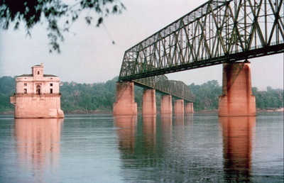
Illinois and Missouri-Chain of Rocks Bridge Madison, Illinois to St. Louis, Missouri
Chain of Rocks Bridge is one of the more interesting bridges in America. It’s hard to forget a 30-degree turn midway across a mile-long bridge more than 60 feet above the mighty Mississippi. For more than three decades, the bridge was a significant landmark for travelers driving Route 66. The bridge’s colorful name came from a 17-mile shoal, or series of rocky rapids, called the Chain of Rocks beginning just north of St. Louis. Multiple rock ledges just under the surface made this stretch of the Mississippi River extremely dangerous to navigate. In the 1960s, the Corps of Engineers built a low-water dam covering the Chain of Rocks. That’s why you can’t see them today. Back in 1929, at the time of the construction of the bridge, the Chain was a serious concern for boatmen.
Read More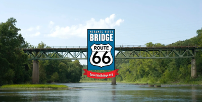
Missouri-Meramec River U.S. 66 Bridge East of Eureka, St. Louis County, Missouri
After its designation in 1926, the course Route 66 took from Illinois to California did not remain static. As practical and political concerns arose, authorities rerouted it to meet them. Meramec River U.S. 66 Bridge resulted from this rerouting. The bridge and the road it supported helped to transform the surrounding area from a wealthy retreat center to a working-class town. More recently, the bridge has become a centerpiece of a State Park devoted to Route 66.
Read More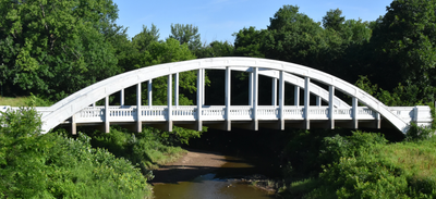
Kansas-Brush Creek Bridge Cherokee County, Kansas
Three and a half miles north of Baxter Springs, Kansas stands the elegant Brush Creek Bridge, the only remaining example of a fixed Marsh Rainbow Arch bridge left on Kansas Route 66. Two other examples, the Spring River and Willow Creek bridges, were dismantled in the early 1990s. The Brush Creek Bridge, also known as the Rainbow Bridge, was part of a project in the early 1920s to connect the mining communities of Galena, Riverton, and Baxter Springs with a concrete road. The unique and graceful Rainbow Arch design was the brainchild of James Barney Marsh, a bridge designer from Iowa, who patented the concrete and steel truss design in 1912. Marsh spent the next two decades erecting approximately 70 of his Rainbow Arch bridges throughout the Midwest, most of them in Kansas, where approximately 35 still remain.
Read More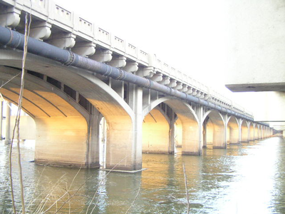
Oklahoma-11th Street Arkansas River Bridge Tulsa, Oklahoma
Built in 1916-1917 over the Arkansas River in Tulsa, the 11th Street Arkansas River Bridge is significant as the first major multi-span concrete bridge in Oklahoma. The bridge became a critical link between downtown Tulsa and the oil fields to the west. The mid-1910s was a period of great activity for Tulsa because of the booming oil economy. Across the Arkansas River, West Tulsa expanded rapidly to become a busy area for refining oil. The increase in traffic and trucking associated with the oil business made replacing the earlier wooden bridge a necessity.
Read More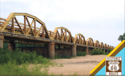
Oklahoma-US-281(Route 66) Bridgeport Bridge in Canadian and Caddo Counties
This bridge was suggested by Oklahoma Department of Transportation to be the most historically significant bridge in the state. Oklahoma does not have the notable old 19th century cast and wrought iron truss bridges of states in the eastern United States. However, it has two unusual truss bridge forms that are unique to the state. The state is noted for its use of through truss bridges that utilize unique K-Parker truss configurations. The state is also noted for its extremely long simple-span truss bridges, most of which are created from state-standard pony truss spans. Of those ultra-long pony truss bridges, this bridge is by far the longest example and the best example. It has been reported to be the longest bridge of any kind in Oklahoma.
Read More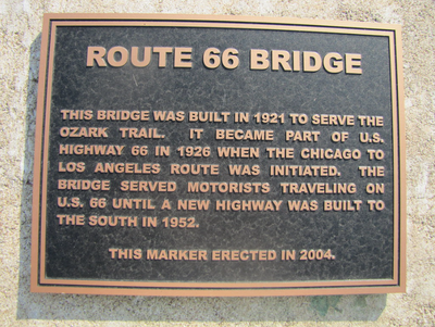
Oklahoma-Bridge #18 at Rock Creek Sapulpa, Oklahoma
Of the great number of bridges built on Route 66, Bridge #18 at Rock Creek is one of the better examples of the remaining steel-truss bridges in Oklahoma. Truss bridges were developed in the mid-1800s and used extensively until World War II, when technology changed and more standardized concrete designs were developed.In terms of lineage, the ancestor of the steel-truss bridge is the beam bridge, usually built of wood and limited in the amount of weight it could support. As a result, early roads generally followed old trails where rivers and creeks were shallow. Even bridges that were quite long were located at shallow crossings.
Read More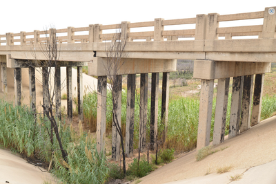
Texas-Route 66 Bridge over the Chicago, Rock Island, and Gulf Railroad Shamrock, Texas
The Route 66 Bridge over the Chicago, Rock Island, and Gulf Railroad is a Route 66 landmark that travelers might miss if they’re not looking for it. The bridge stands in the arid plains eight miles east of Shamrock, five-and-a-half miles west of the Oklahoma State line, and 12 miles southeast of Wheeler.Paved in 1932, Route 66 was the primary road in this development. The highway passed through numerous small towns, most of which had fewer than 500 residents. The high plains of the Panhandle are relatively flat, so the area didn’t require many bridges, which makes the bridge in Wheeler County somewhat unusual. Another unusual feature is that the bridge carried both automobile and train traffic. Designed as a double-decker, the bridge has train tracks for the Chicago, Rock Island, and Gulf Railroad running along a deck 25 feet below the roadbed of Route 66.
Read More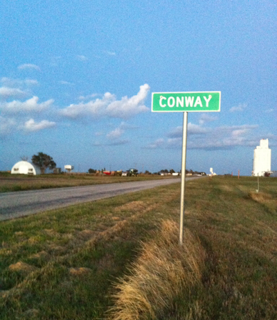
Texas-Route 66, SH 207 to Interstate 40 Conway, Texas
When Interstate 40 was completed through Carson County, this section of Route 66 became Texas Farm Road 2161, part of the county’s highway system. Today it is the longest and best preserved section of Route 66 in Texas, carrying local traffic and travelers out to capture the distinctly American ambiance of old Route 66. It was listed in the National Register of Historic Places in 2007. Early in the 1900s, this roadway was little more than a dirt path. In 1930, the path was paved, and by 1940, it was a bustling highway. An aerial view today looks much the same as it did then, a straight line of highway framed on both sides by square agricultural fields in various shades of brown, yellow, and green.
Read More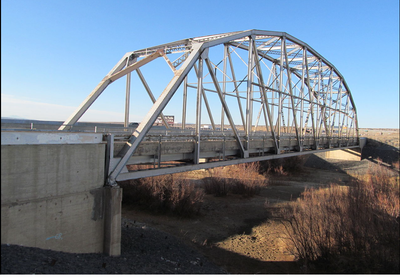
New Mexico-Rio Puerco Bridge Rio Puerco, New Mexico
Heading west out of Albuquerque on Route 66, travelers can enjoy a scenic descent from Nine Mile Hill into the Rio Puerco Valley, where a Parker through truss bridge crosses the steeply eroded banks of the Rio Puerco River. The valley is the site of Laguna Pueblo, the home of Puebloans since the 1300s. Because the Rio Puerco is known for its violent flooding and severe erosion, the State Highway Department specifically chose a Parker through truss bridge design for the Rio Puerco Bridge to eliminate the need for a center pier and prevent washouts. The bridge consists of 10 panels measuring 25 feet in length, each with its top cord at a different angle, as is characteristic of Parker truss design bridges. The 25-foot wide deck is concrete with an asphalt surface and rests on steel stringers. This design was selected partially because it was commonly used during the late-1920s and 30s, but also because it was particularly suitable for this bridge, which needed to withstand a river capable of massive flooding that had washed away previous bridges along the Rio Puerco.
Read More
Arizona-Querino Canyon Bridge Houck, Arizona
The Querino Canyon Bridge is picturesquely situated over a rugged and beautiful canyon just outside Houck, Arizona. Designed by the Arizona Highway Department, the bridge is a representative example of early highway truss design: 77 feet long, 20 feet wide, and comprised of a concrete-decked steel trestle with three Pratt deck trusses supported by steel piers. Concrete abutments support the bridge from below and steel lattice guardrails typical of the period line the roadway. This section of the highway became a county road during the 1960s after construction of Interstate 40. The Querino Canyon Bridge remains intact, carrying local traffic on the Navajo Indian Reservation. It was listed in the National Register of Historic Places in 1988.
Read More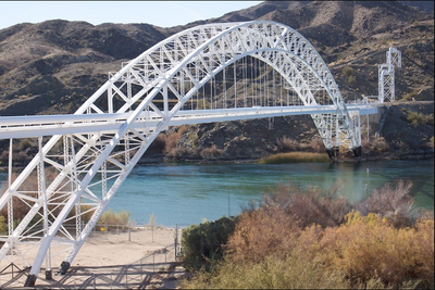
Arizona – California-Old Trails Bridge Topock, Arizona
An innovative piece of engineering, one enormous span of 600 feet supports the 800-foot bridge that crosses the Colorado River in Topock, halfway between Yuma and the Utah border. The bridge carried automobile traffic over the Colorado River from 1916 until 1948. In Topock, engineers used a unique cantilever method of construction assembling bridge halves on their sides on the ground and hoisting them into place using a ball-and-socket center hinge. This meant that the structure was not supported by traditional spans from the ground up as it was being built. The use of the cantilever was a daring move for its time, creating the longest arched bridge in America. At 360 tons, it was the lightest and longest bridge of its kind. From the day it opened, this graceful arch and the deck it supported were a pivotal Colorado River crossing, first on the transcontinental National Old Trails Road and, by 1926, on Route 66.
Read More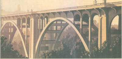
Colorado Street Bridge Pasadena, California
With its majestic arches rising 150 feet above the deeply cut Arroyo Seco, the Colorado Street Bridge was proclaimed the highest concrete bridge in the world upon completion in 1913. The bridge impressed travelers from the day it opened. Until then, the crossing of the Arroyo Seco required horses and wagons to descend the steep eastern slope, cross a small bridge over the stream, and then climb the west bank through Eagle Rock Pass. Given this harsh topography, the Colorado Street Bridge proved a challenge to design and build. Solid footing eluded engineers in the seasonally wet arroyo bed. These engineering challenges were solved when engineer John Drake Mercereau conceived the idea of curving the bridge 50 degrees to the south. This solution coupled with a graceful design of soaring arches and a curved deck created a work of art that received Historic Civil Engineering Landmark designation and listing in the National Register of Historic Places. Mercereau chose to support the bridge’s 28-foot-wide roadway and five-foot-wide sidewalks using spandrel construction. In this system, support columns rest on the expansive arched ribs of the bridge. Mercereau’s design also included classical balusters and ornate cast-iron lamp posts supporting multi-globed lamps.
Read More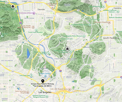
Arroyo Seco Parkway Los Angeles, California
A drive through the Arroyo Seco is a ride through history. Some call the Arroyo Seco Parkway the starting point for Los Angeles car culture. It was the first “freeway” in the West and an engineering marvel of its time. Add to that the distinction and imprint of historic Route 66 and you have the makings for the perfect adventure by car. Upon its completion in 1940, it was designated an alignment of Route 66 becoming the first stretch of the Mother Road to run over a modern, limited-access highway in the nation. If the spread of the freeway concept, eventually embodied by the national Interstate Highway System, spelled the beginning of the end for Route 66, the Arroyo Seco Parkway still stands as a remarkable piece of urban transportation history and holds a unique place in the story of Route 66.
Read Morenational park service

Visit Route 66 in all states through which it passes
U.S. Highway 66 -- popularly known as Route 66 or the Mother Road -- holds an elevated place in American consciousness and tells diverse stories of a mobile nation on the road. Discover this shared heritage through historic places you can still experience today, which are reminders of our past and the influence the automobile has had on our lives and nation today. There are more than 250 buildings, bridges, road alignments and other sites along Route 66 that are listed on the National Register of Historic Places. This travel itinerary highlights over 100 of those sites, and is part of the National Park Service's Share Our Heritage Travel Itineray series. Enjoy your trip and visiting these special places along historic Route 66!
Read More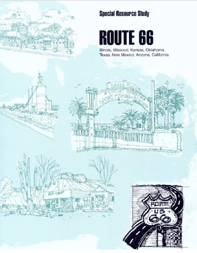
Route 66 Special Resource Study
The history of this country has included a number of periods of human migration. Shortly after its emergence from the War of Independence, the new nation saw the steady outward drift of its people across the Appalachians into the Mississippi and Ohio Valleys. Navigable rivers and foot trails and military roads were the earliest transportation network. While some turnpikes leading to and from burgeoning centers of trade were surfaced with gravel or "pounded stone," most roads were improved only to the extent of removing stumps, boulders, and other major irregularities. Most backwoods trails remained impassable to wheeled vehicles, especially during the winter or subsequent spring thaws. For the most part, bridges were nonexistent; early travelers forded smaller streams and crossed larger ones by ferry.
Read MoreFederal Highway administration
The Trailblazers
No history of road construction in the United States can be complete without an acknowledgment of the difficult pioneering work performed by engineers of the U.S. Bureau of Public Roads (now called Federal Highway Administration [FHWA]) in the early days of direct Federal construction on national forest and park lands. The men who located, designed, and built the initial highways in the Federal domain, often under adverse conditions, completed important links and extensions that were essential in the development of the Nation's highway systems.
Read More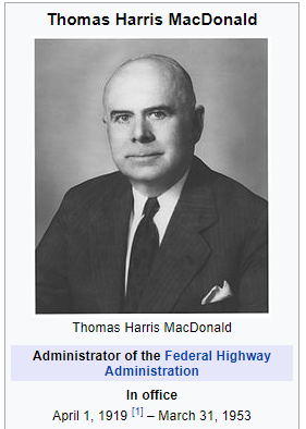
Thomas H. Macdonald
Thomas H. MacDonald, who headed the U.S. Bureau of Public Roads (BPR) from 1919 to 1953, is a towering figure in the history of highways. He helped to revitalize the Federal-aid highway program by initiating a system focus, with emphasis on roads that were “interstate in character,” in the Federal Highway Act of 1921. By the time he left office, he has ushered the Nation to the brink of the Interstate era. During these years, he was recognized as the greatest authority on highway development and a man of unquestioned integrity and commitment.
Read More
Highway History
The Federal Highway Administration (FHWA) and its predecessor agencies have been directly engaged in the location, design, and construction of public roads, giving access to and through the National Parks, the National Forests, and other areas within the Federal domain since 1905. The record of intergovernmental cooperation with the other agencies concerned has been outstanding to this day. In 1905, the same year of the U.S. Forest Service was established, the Division of Tests of the Bureau of Chemistry and the Office of Public Road Inquiries in the U.S. Department of Agriculture were consolidated into the Office of Public Roads. In spite of extremely limited staff and resources, immediate plans were made to offer a professional service in the area of road construction to other agencies of the Federal Government. This work was essentially advisory in nature. The Federal-Aid Road Act, approved July 11, 1916, is historic as it established the basis for the Federal-Aid highway program in cooperation with the States. To carry out the provisions of the Act, a complete Federal highway engineering organization was needed throughout the country. In 1917 10 districts were established, with each district given the responsibility for the construction of rural Post Roads in cooperation with the State highway departments, and for the survey, construction, and maintenance of National Forest roads in cooperation with the U.S. Forest Service and the State and local authorities. The Agricultural Appropriation Acts of 1912 and 1913 provided funds that could be expended on construction of roads and trails serving the National Forest, and for the first time offered a sustained source of revenue for road improvement purposes in the public domain.
Read MoreU.S. Bureau of land management
Route 66 America's Iconic Mother Road Map & Guide
For thousands of years, Native Americans developed a network of trails from spring to spring across the High Desert to trade with tribes along the Pacific Coast. By the 1850s, the U.S. Army was building roads over/near the trails to support westward expansion. Railroads followed the trails where feasible to get access to water and supplies. New wagon roads were built to follow the railroads, and many of these roads would become routes for automobiles. The first car crossed the High Desert in 1903. However, desert’s sandy roads and steep grades were difficult for cars. In 1911, San Bernardino County built the first road for cars to cross the Mojave Desert. In 1912, the Old Trails Road, later named National Old Trails Road, was built. By 1918, it was the preferred transcontinental auto route from New York to Los Angeles. Between 1910 and 1920, vehicle ownership grew from 500,000 to almost 10 million. A national highway system was needed to replace America’s disjointed network of badly maintained roads and trails. Congress first introduced legislation for public highways in 1916 (Federal Aid Highway Act). The Act was revised in 1921 and again in 1925, which finally authorized construction of a national highway system. On November 11, 1926, the Chicago to Los Angeles route, was officially designated U.S. Highway 66, more popularly known as Route 66. The route extended 2,448 miles across eight states beginning in Chicago, Illinois and ending in Santa Monica, California. The “Mother Road” was born.
Read More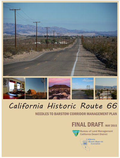
California Route 66 - Needles to Barstow Corridor Management Plan
The California Historic Route 66 Association and the California Desert District of the Bureau of Land Management (BLM) have teamed up with their governmental and nongovernmental organization partners to help preserve the history of Route 66 through the desert and develop strategies for educating visitors from both nearby and afar about its significant cultural and natural landscape features. The effort will also look for ways to increase economic activity through enhanced recreation and heritage tourism opportunities for visitors to its gateway communities. The BLM hired a multidisciplinary team led by Lardner/Klein Landscape Architects (L/KLA) to assist with this planning effort. L/KLA has prepared corridor management plans for byways and heritage touring routes throughout the United States. One of the first project tasks is to reach out to communities along Route 66, from Barstow to Needles, for their ideas, and suggestions as to how this effort can help to preserve and enhance the heritage and nature-based tourism opportunities that are found along the corridor and in the region.
Read MoreThe Official Federal Land Records Site
The BLM was established in 1946, but its roots go back to the years after America’s independence, when the young nation began acquiring additional lands. At first, these lands were used to encourage homesteading and westward migration. The General Land Office was created in 1812 to support this national goal. Over time, values and attitudes regarding public lands shifted, and President Harry S. Truman, by means of a government reorganization, merged the GLO and another agency, the U.S. Grazing Service, creating the BLM.
Read More